The Department of Transportation unveiled its WalkNYC initiative, a program that will bring comprehensive pedestrian maps to all five boroughs.
The DOT enlisted the help of PentaCityGroup, a consortium of urban planners, engineers, designers, cartographers and geographical information specialists, to solve the problem. Their goal? To create an information-packed map that would orient pedestrians and help them find the gems each NYC neighborhood has to offer. The first of these new information kiosks was installed earlier this week in Chinatown (they’re already located at every Citi Bike station), and it’s expected that others will be popping up in midtown Manhattan, Long Island City in Queens and Prospect Heights in Brooklyn this summer, with more to follow in other neighborhoods next year.
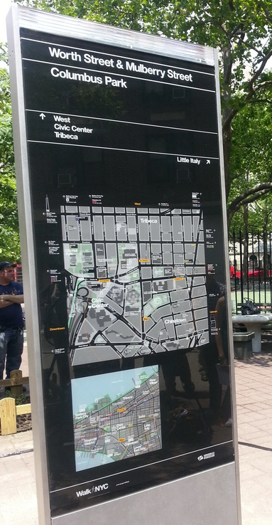
Each side of the kiosk displays a map showing the streets within a five-minute walking radius and another that shows your current area in relation to a larger swath of the city. The maps are layered with information including street names, bike paths, subway lines and entrances, parks, playgrounds, restaurants and highly-detailed sketches of major landmarks.
In each of the four initial areas, DOT worked with community partners to identify, research, and observe the popular destinations, primary pedestrian routes, and key decision-making points of each neighborhood. Through careful research, DOT also located the difficult-to-navigate parts of each neighborhood, focusing on the routes between transit services, landmarks and public spaces.
This research created a detailed picture of each area, which DOT used to tailor a placement strategy. The research also forms the basis of the site location and network planning standard that will be applied citywide. DOT has developed a variety of sign sizes to accommodate different environments.
WalkNYC maps are also installed at Citi Bike station kiosks, to expand the wayfinding network and provide valuable information for pedestrians, in addition to Citi Bike users.
The four initial areas and community partners for WalkNYC are:
- Chinatown with the Chinatown Partnership and the Chinatown BID
- Long Island City with the LIC Partnership
- Herald Square with the 34th Street Partnership and the Garment District with the Fashion Center BID
- Prospect Heights and Crown Heights with the Heart of Brooklyn and the Brooklyn Children’s Museum
We expect to see signs in Harlem soon.
If you come across an ideal location for a sign, tweet the location via Twitter using the hashtag #WalkNycSignForHarlem.
http://www.wired.com/design/2013/07/nyc-signs/
http://www.nyc.gov/html/dot/html/pedestrians/walknyc.shtml